
Genesys International unveils 3D mapping plan of urban cities, to sell as service
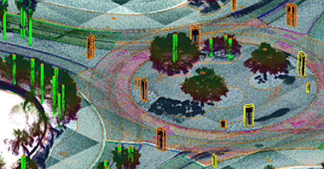
Genesys International has announced to produce high resolution 3D maps that can help in creating various models in a city and install solar panels accordingly as well as automotive companies can use this data to train self-driving cars.
Sajid Malik, chairman and managing director (CMD) of Genesys International stated that the 'India 3D Maps' initiative is fuelled by the liberalised geospatial data and services policy of the country. Taking advantage of this, Genesys seeks to build high resolution 3D maps that will cover over 5 crore linear kilometres of road across the country.
The company unveiled its plan to produce 3D maps on Wednesday during a program which was inaugurated by NITI Aayog chairman Amitabh Kant.
The company is starting off its project with metropolitan cities and adjoining urban areas, which Malik said are the obvious consumers of newer technologies. Talking of how it can boost metro markets, Malik said, “Data of the kind that we are generating can be used for a wide range of uses in city administration – roads, urban planning, smart property taxation and so on.”
To generate the data, Malik said that Genesys uses aerial sensors, panoramic cameras and Lidar sensors to create its 3D mapping data pool. The company applies its own artificial intelligence (AI) tools for better recognition of buildings to create its map. “The range of 3D data that we are generating can help in creating various models, such as shadow models based on sunlight received by a city. This can help in solar panel installation and planning in a city,” Malik said.
With its 3D mapping initiative, Genesys is targeting a wide range of industries to sell its data to, for a fee. Malik said that such data can be sourced by automotive companies for offering 3D maps to train autonomous cars. “Our 3D mapping data includes contour information of terrain, which can be a key to analysing, for instance, battery consumption in electric cars and better navigation routes in advanced driver assistance systems (ADAS) equipped cars,” Malik said.
He further added that the company will look to source its data to private and government entities in fields such as utility services, telecom companies, renewable energy providers, consumer level navigation and more. While they have not disclosed a list of clients for the 3D mapping service yet, Genesys recently conducted 3D mapping of the Worli area in Mumbai, in partnership with the Brihanmumbai Municipal Corporation (BMC).
Next Article