
How Satellite Data Can Help India Respond to Water Stress
As water stress intensifies across India, improving the accuracy of soil moisture data is becoming increasingly important for agriculture, drought response, and long term water management. Dr. Zsófia Kugler of the Budapest University of Technology and Economics explains how satellite-based research and international scientific cooperation can support more reliable environmental monitoring.
Q1. India is facing increasing water stress and climate-related challenges. From your perspective, why is soil moisture such a critical variable in this context?
Soil moisture is a fundamental parameter in the Earth system, even though it is often not directly visible. The amount of water stored in the upper soil layer strongly influences how heatwaves develop, how crops respond to weather conditions, and how water circulates between the land surface and the atmosphere. In countries like India, where a large proportion of agriculture depends on rainfall, soil moisture conditions can determine crop yields and, in extreme cases, food security. When the soil dries out, heatwaves can intensify and persist longer, while insufficient moisture during key growing periods can significantly reduce agricultural output. Understanding and monitoring soil moisture is therefore essential for both climate adaptation and water management.
Q2. Your current work involves collaboration with NASA on satellite-based soil moisture measurements. What is the objective of this cooperation?
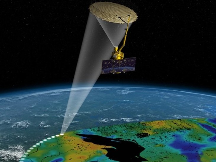
The main objective is to improve the reliability of satellite-derived soil moisture data. Satellites such as SMAP and the recently launched NISAR mission provide global coverage, scanning the Earth’s surface every few days using L-band microwave signals. However, satellite observations are indirect measurements. They must be validated against ground-based data to ensure that they accurately represent real conditions. At BME, we contribute to this process by providing detailed in-field measurements and long-term soil moisture datasets from Hungarian observation sites. By comparing these ground measurements with satellite products, we can identify discrepancies, refine algorithms, and ultimately improve the accuracy of global datasets.
Q3. How do these improvements translate into practical benefits, particularly for countries like India?
Improved data quality has direct practical implications. Reliable soil moisture information can support agricultural planning, including irrigation scheduling and crop-yield estimation. It also contributes to drought monitoring and early warning systems. In India, where large agricultural areas depend on monsoon rainfall, this information is particularly valuable. Satellite data can help identify regions experiencing water stress, allowing for more targeted interventions. In addition, soil moisture is a key input for climate and weather models. Better data improves the accuracy of forecasts, including the prediction of heatwaves and dry periods.
Q4. What makes L-band microwave satellites especially suitable for soil moisture observation?
L-band microwave signals have a relatively long wavelength, which allows them to penetrate vegetation and the upper soil layer. This makes them particularly sensitive to moisture content in the top few centimetres of soil. Unlike optical sensors, microwave instruments can operate day and night and are less affected by cloud cover. This is essential for regions with frequent cloudiness, such as during the monsoon season. These characteristics make L-band systems highly suitable for continuous, large-scale monitoring of soil moisture.
Q5. BME combines research, education, and international collaboration. How is this reflected in your teaching?
Our teaching is closely linked to ongoing research activities. Students are introduced to the theoretical foundations of remote sensing, hydrology, and data analysis, but they also work with real datasets and practical case studies. In some courses, students engage directly with satellite data and validation techniques. They learn how to interpret measurements, understand uncertainties, and apply numerical models. This approach ensures that graduates are not only familiar with concepts, but also capable of working with the tools and data used in professional and research environments.
.jpg)
Q6. BME has developed strong international connections, including with NASA and European partners. How does this benefit students?
International collaboration is an integral part of our work. Through partnerships with organisations such as NASA and the European Space Agency, as well as cooperation with universities worldwide, we are part of a global research network. For students, this means access to international expertise, exposure to global challenges, and opportunities to participate in joint projects. It also enhances the recognition of their degrees and supports their future careers. In addition, initiatives such as international summer schools bring students together from different countries, creating a diverse learning environment.
Q7. How relevant are these programmes for Indian students in particular?
The relevance is very high. Many of the challenges we address in our research (such as drought monitoring, water management, and climate adaptation) are directly applicable to the Indian context. Students from India can gain a strong theoretical foundation and practical experience with advanced technologies, including satellite data analysis and numerical modelling. They can then apply this knowledge in their home country, adapting it to local conditions and needs. In this sense, studying at BME provides both international perspective and locally applicable expertise.
Q8. What role do you see for the next generation of engineers in addressing global water challenges?
The challenges related to water and climate are becoming more complex and interconnected. Engineers will need to work across disciplines, combining knowledge from hydrology, remote sensing, data science, and environmental engineering. They will also need to translate scientific knowledge into practical solutions that can be implemented at scale. This includes improving data systems, designing efficient water management strategies, and supporting policy decisions with reliable information. Education is a key factor in this process. By training engineers with strong analytical skills and a global perspective, universities can contribute to more resilient societies.
Q9. What message would you give to Indian students and their parents who are considering BME?
I would emphasise that BME offers a rigorous and internationally connected education. Students learn from active researchers, work with real data, and become part of a global scientific community. For those interested in climate, water, or space-related technologies, the programmes provide relevant knowledge and practical skills. At the same time, the international environment helps students develop a broader perspective. This combination prepares graduates to address complex challenges, whether they choose to build their careers in Europe, India, or anywhere else.
NOTE: No TechCircle Journalist was involved in the creation/production of this content.
Next Article